


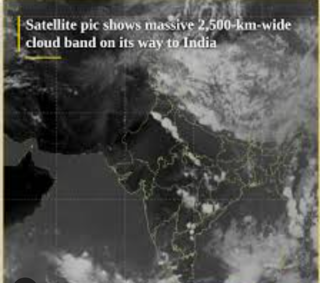
Inside the 2,500-Kilometer Cloud Band Shielding North and Central India
A Sky Cast in White
For weeks, North and Central India endured an unrelenting heatwave. Temperatures soared to a scorching 48.2°C in parts of Rajasthan, while major metropolitan regions such as Delhi-NCR, Punjab, and Haryana baked under extreme heat.
But a sudden atmospheric shift dramatically changed the weather pattern.
Thermal infrared imagery captured by India’s advanced weather satellite INSAT-3DS revealed a striking meteorological phenomenon: a massive, continuous cloud band stretching over 2,500 kilometers from west to east.
Originating as far west as Pakistan, this extensive atmospheric system has blanketed large parts of the subcontinent—covering Punjab, Haryana, Delhi, Uttar Pradesh, and central India—before extending toward the Bay of Bengal.
The Anatomy of the Colossus
Meteorologists at the India Meteorological Department (IMD) explain that this cloud belt is the result of a powerful interaction between multiple weather systems:
- Active Western Disturbance: A low-pressure system originating from the Mediterranean, moving across the western Himalayas
- Dual-Ocean Moisture Incursion: Moisture-rich winds from both the Arabian Sea and the Bay of Bengal
When these moisture streams collided with the intensely heated air over the Indo-Gangetic plains, they triggered severe atmospheric instability. The surface heat acted as fuel, forcing rapid upward movement of moist air through intense convection.
This led to the formation of large Mesoscale Convective Systems (MCS)—massive clusters of thunderstorms visible in satellite imagery as bright white regions. These cloud tops indicate extremely high-altitude storm formations reaching colder atmospheric layers.
From Inferno to Inundation: The Impact
While the system has brought a sharp and welcome drop in temperatures, it has also introduced significant weather risks across multiple states.
| Weather Element | Expected Phenomena | Affected Regions |
|---|---|---|
| Precipitation | Heavy to very heavy rainfall | Uttarakhand, Uttar Pradesh, Delhi-NCR |
| Severe Weather | Thunderstorms, lightning, hailstorms | Punjab, Haryana, Madhya Pradesh |
| Wind Activity | Gusty winds, dust storms | Gujarat, Rajasthan, Central India |
Atmospheric Flow
Pakistan ──(Moisture Flow)──> North & Central India ──> Bay of Bengal
        │
        └── Clashes with Extreme Surface Heat
                        │
                        ▼
               2,500 KM Cloud System
               ┌──────────┴──────────┐
               ▼                     ▼
     Severe Thunderstorms     Rapid Cooling Effect
The Monsoon Connection
The timing of this system is particularly significant. While the Southwest Monsoon continues its gradual advance across southern India, this northern pre-monsoon activity is acting as an independent atmospheric trigger.
IMD Observation: The interaction between intense surface heating and sudden moisture influx is a known feature of the pre-monsoon transition. However, the scale of this 2,500-km cloud system is among the largest observed in recent years.
Conclusion
As the system moves eastward, it is expected to gradually release its energy, bringing heavy rainfall and a noticeable drop in temperatures. While humidity levels will rise, the oppressive heatwave conditions are likely to ease significantly.
For millions across North and Central India, the arrival of this vast cloud shield is a dramatic—but welcome—shift from extreme heat to atmospheric relief.