New UN World Map Depicts Arunachal Pradesh, Aksai Chin Separately Amid India-China Territorial Dispute
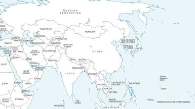
New UN World Map Draws Attention in India Over Depiction of Arunachal Pradesh and Aksai Chin
New Delhi: A newly released United Nations world map has triggered fresh discussion in India over its depiction of Arunachal Pradesh and Aksai Chin, two strategically sensitive areas at the centre of the long-running India-China territorial dispute.
The map, published on July 1 during discussions surrounding a United Nations General Assembly initiative known as the “Correct the Map” resolution, has drawn attention because Arunachal Pradesh and Aksai Chin are depicted separately amid the competing territorial claims of India and China.
How Arunachal Pradesh and Aksai Chin Are Depicted
In the map's depiction of northeastern India, Arunachal Pradesh is shown with boundary lines in relation to Assam and China. The map does not display a conventional state boundary between Arunachal Pradesh and Nagaland.
Aksai Chin is also depicted separately, with India shown to its west and China to its east. The United Nations has not provided a specific explanation for these particular cartographic representations.
Both areas remain highly sensitive in India-China relations. India maintains that Arunachal Pradesh is an integral part of the country, while China claims the region as part of what it refers to as “South Tibet.” India also claims Aksai Chin as part of its territory, while China exercises control over the area.
What Does the Map Show About Jammu and Kashmir?
The map also depicts the Line of Control (LoC) in Jammu and Kashmir using a dotted line.
An accompanying note explains that the dotted line represents approximately the LoC in Jammu and Kashmir agreed upon by India and Pakistan. It also states that the final status of Jammu and Kashmir has not been agreed upon by the two sides.
What Is the UN's 'Correct the Map' Initiative?
The map is linked to a United Nations General Assembly initiative aimed at promoting more accurate and equitable cartographic representation of the world's regions, particularly Africa.
The initiative is connected with discussions on alternative world map projections, including the Equal Earth projection, which seeks to represent the relative size of landmasses more accurately than the traditional Mercator projection.
However, the resolution does not legally settle international territorial disputes or determine sovereignty over contested regions. It also does not, by itself, endorse any particular political depiction of disputed territories. (Source: United Nations-related reporting and India's Ministry of External Affairs position.)
India's Position
India supported the UN initiative but made it clear that its vote should not be interpreted as accepting any particular political map or territorial depiction.
The Ministry of External Affairs has stated that India's sovereign territory, including the Union Territories of Jammu and Kashmir and Ladakh, must be represented according to India's official map. The government has maintained that any inaccurate or misleading depiction of India's territory is unacceptable. :contentReference[oaicite:1]{index=1}
India has also reiterated that Arunachal Pradesh is an integral part of the country and that external claims do not alter its position on the region. :contentReference[oaicite:2]{index=2}
Why the Map Has Drawn Attention
The depiction has attracted attention because Arunachal Pradesh and Aksai Chin are among the most sensitive areas in the unresolved India-China boundary dispute. The cartographic representation of such disputed regions can therefore have diplomatic and political significance, even when a map does not itself determine territorial sovereignty.
The latest development comes against the backdrop of continuing India-China disagreements over their disputed boundary. The issue has renewed discussion in India about how international organisations represent contested territories on official maps.